Categories
Caravan Park Invitations

Bungendore Caravan Park in Bungendore New South Wales

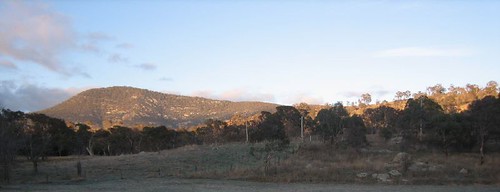
Bungendore is a town in the Southern Tablelands of New South Wales, Australia, in Palerang Council. It is on the Kings Highway near Lake George, the Molonglo River Valley and the Australian Capital Territory border. It has become a major tourist centre in recent years, popular with visitors from Canberra and some of it has heritage protection. It has expanded rapidly in recent years as a dormitory suburb of Canberra.

The Old Stone House, Bungendore, NSW
Creative Commons License photo credit: Brenden Ashton

The town remained a railhead from 1885 until the line reached Queanbeyan in 1887. Partly because of the coming railway, the 1880s proved a boom period for the town and the population increased from 270 in 1881, to 700 by 1885. By then, Queanbeyan was emerging as the major town in the area.

In 1894, gold was discovered at Bywong. In 1901, Lake George and Bungendore were proposed as sites for the nation’s capital city. This did not eventuate, as the drawcard of Lake George failed to impress the visiting Commissioners of the time.

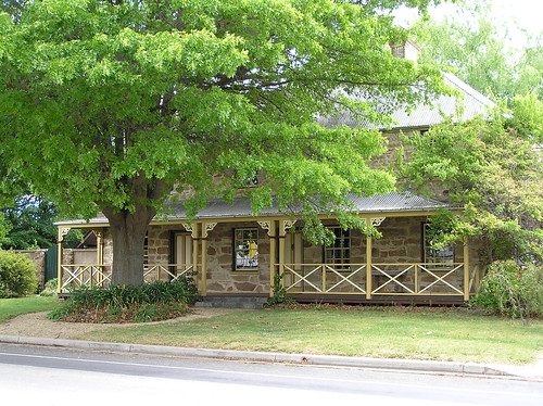
Hideaway in Bungendore, New South Wales.

If you have visited any caravan, tourist or holiday park in or near Bungendore we would welcome your comments, reviews or photos. If you own or manage a caravan park in or near Bungendore New South Wales and you are not listed on our site then please list for free.

Do you own a farm or property in or near Bungendore that would have facilities for caravans or campers? We would like to hear from you and please describe the facilities that would be available such as electrical power, amenities, cooking or BBQ facilities etc.

If you live in or have visited Bungendore then we would like to receive your reviews of activities and facilities that would be suitable for tourists and holiday makers.

You can add your comments in the form below to assist is to build Australia’s most comprehensive Directory of Caravan Parks and Photos.

Photo submission guidelines are available here.

We gratefully acknowledge the information provided by Wikipedia under a Creative Commons Attribution-ShareAlike 3.0 Unported License. The full article can be viewed at Wikipedia


View Larger Map

Categories
Caravan Park Invitations

Captains Flat Caravan Park in Captains Flat New South Wales

RayFord
Creative Commons License photo credit: bettyb258

Captains Flat is a town in the Southern Tablelands of New South Wales, Australia, in Palerang Shire. It is south of Queanbeyan.

Captains Flat has a permanent population of 400 these days.

It is suggested that a bullock named “Captain” from Foxlow station, 12 km away, grazed here and hence the place name.

The area was originally inhabited by Ngarigu Aboriginals prior to European settlement. The town formed as a result of mining for gold, silver, lead, zinc, copper and iron pyrites in the hills surrounding the upper reaches of the Molonglo River. The town boomed from 1881 to 1899 then went into a rapid decline until 1939 when rail access revived mining activity for another 23 years.

If you have visited any caravan, tourist or holiday park in or near Captains Flat we would welcome your comments, reviews or photos. If you own or manage a caravan park in or near Captains Flat New South Wales and you are not listed on our site then please list for free.

Do you own a farm or property in or near Captains Flat that would have facilities for caravans or campers? We would like to hear from you and please describe the facilities that would be available such as electrical power, amenities, cooking or BBQ facilities etc.

If you live in or have visited Captains Flat then we would like to receive your reviews of activities and facilities that would be suitable for tourists and holiday makers.

You can add your comments in the form below to assist is to build Australia’s most comprehensive Directory of Caravan Parks and Photos.

Photo submission guidelines are available here.

We gratefully acknowledge the information provided by Wikipedia under a Creative Commons Attribution-ShareAlike 3.0 Unported License. The full article can be viewed at Wikipedia


View Larger Map

Categories
Caravan Park Invitations

Tharwa Caravan Park in Tharwa Australian Capital Territory

Sunrise - Mt Tennant
Creative Commons License photo credit: Jimee, Jackie, Tom & Asha

Tharwa (postcode 2620) is a small village within the Australian Capital Territory, 35 kilometres south of Canberra, the capital city of Australia. At the 2006 census, Tharwa had a population of 109.

The village is located on the banks of the Murrumbidgee River and at the junction of Tidbinbilla and Naas Roads, and Tharwa Drive. The main public buildings are a general store, a preschool and primary school (now closed), Saint Edmund’s Church, a cemetery, a community hall and tennis courts. The annual Tharwa Fair was hosted by the school, and was held in May until 2006. The Tharwa Fair is now organised by Tharwa Preschool.

Rebirth of Tharwa Bridge

If you have visited any caravan, tourist or holiday park in or near Tharwa we would welcome your comments, reviews or photos. If you own or manage a caravan park in or near Tharwa Australian Capital Territory and you are not listed on our site then please list for free.

If you live in or have visited Tharwa then we would like to receive your reviews of activities and facilities that would be suitable for tourists and holiday makers.

You can add your comments in the form below to assist is to build Australia’s most comprehensive Directory of Caravan Parks and Photos.

Photo submission guidelines are available here.

We gratefully acknowledge the information provided by Wikipedia under a Creative Commons Attribution-ShareAlike 3.0 Unported License. The full article can be viewed at Wikipedia


View Larger Map

Categories
Caravan Park Invitations

Churchill Caravan Park in Churchill Victoria

Churchill is a town in the Latrobe Valley, located in central Gippsland in the east of Victoria, Australia. The town had a population of 4,588 at the 2006 census, and is part of the Latrobe City local government area. The town was named in honour of former British leader Sir Winston Churchill.

Churchill has one defining and quite unique landmark, that being a huge replica of Winston Churchill’s cigar (known locally as “the big cigar”). Originally it was anticipated that five of these would be built around points of the town centre’s edge, but only one was actually ever built. The Binishell was also a prominent feature visible from much of the eastern side of town, this has since been pulled down.

Near the base of the cigar is a commemorative brick wall built by the Rotary Club of Hazelwood. It gives the names of the first families to move into the town.

If you have visited any caravan, tourist or holiday park in or near Churchill we would welcome your comments, reviews or photos. If you own or manage a caravan park in or near Churchill Victoria and you are not listed on our site then please list for free.

If you live in or have visited Churchill then we would like to receive your reviews of activities and facilities that would be suitable for tourists and holiday makers.

You can add your comments in the form below to assist is to build Australia’s most comprehensive Directory of Caravan Parks and Photos.

Photo submission guidelines are available here.

We gratefully acknowledge the information provided by Wikipedia under a Creative Commons Attribution-ShareAlike 3.0 Unported License. The full article can be viewed at Wikipedia


View Larger Map

Categories
Caravan Park Invitations

Nyora Caravan Park in Nyora Victoria

Sascha and Ember
Creative Commons License photo credit: jennikate

Nyora is a town in south Gippsland, Australia. At the 2006 census, Nyora had a population of 545.

The Post Office opened around September 1890 replacing an office at nearby Lang Lang East open since 1885.

The town’s railway station and general store were included in the popular ABC TV program Something in the Air. The township featured in the TV series was known as “Emu Springs”.

Nyora is home to the former V/Line railway station of the same name, which served primarily as a freight and goods transfer facility as well as the branch station for the former Foster – Leongatha and Wonthaggi lines.

The railway station presently serves as part of the South Gippsland Railway — a community based heritage / tourist railway organisation, with its operations base at Korumburra.

Golfers play at the course of the Lang Lang Golf Club on the South Gippsland Highway, Nyora.
Nyora is 12 km from Lang Lang, and 11 kilometres from the nearest beach.

If you have visited any caravan, tourist or holiday park in or near Nyora we would welcome your comments, reviews or photos. If you own or manage a caravan park in or near Nyora Victoria and you are not listed on our site then please list for free.

If you live in or have visited Nyora then we would like to receive your reviews of activities and facilities that would be suitable for tourists and holiday makers.

You can add your comments in the form below to assist is to build Australia’s most comprehensive Directory of Caravan Parks and Photos.

Photo submission guidelines are available here.

We gratefully acknowledge the information provided by Wikipedia under a Creative Commons Attribution-ShareAlike 3.0 Unported License. The full article can be viewed at Wikipedia


View Larger Map